


Research Case Study
Insight: Investigating North Norfolk’s chalk reef using rapid 3D reconstructions
Winner: Celebrating Excellence in Research and Impact Awards 2020 – Best Research Impact by an Early Career Researcher in the Faculty of Science and Health
-
Tagged under
Environment and sustainability
Technology, data and innovation
-
Lead Academics
Dr Jon Chamberlain
Jessica Wright
Dr Alba Garcia Seco De Herrera
Dr Louis Clift
Reef habitats are under increasing threat, and with them the ecosystems they support. Essex researchers are collaborating with organisations around the world to develop state-of-the-art techniques for rapid marine surveying and reef conservation using 3D technology to understand changing marine ecosystems.
One project closer to home is with Natural England, surveying chalk reefs on Norfolk’s Cromer Shoal Marine Conservation Zone. By combining computer vision and artificial intelligence algorithms with multi-sensor surveying, it is faster, more accurate and comprehensive than traditional surveying methods.
The challenge
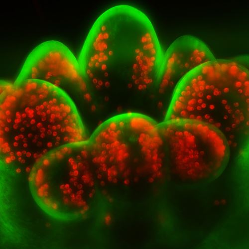
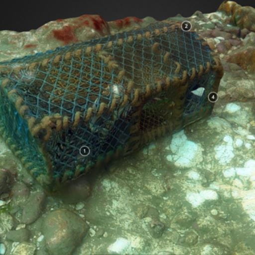
The rugged and complex structures of the chalk bed in Norfolk’s Cromer Shoal Marine Conservation Zone (MCZ) provide habitat for a wide range of marine species. The edible crab Cancer pagurus (also known as Cromer crab) and lobster Homarus gammarus are common in this area and are target species for fisheries that are embedded in the history and culture of North Norfolk coastal towns.
In December 2018, damage to areas of elevated chalk bed in the MCZ was reported to Natural England.
Along with the Eastern Inshore Fisheries and Conservation Authority (EIFCA), Natural England wanted to undertake an impartial investigation into these reports to develop policies to safeguard the natural environment and preservation of fishing habitats.
What we did
The Marine Technology Research Unit (MTRU) at Essex’s School of Computer Science and Electronic Engineering have been working on techniques to rapidly monitor marine environments using multiple cameras attached to remotely operated vehicles (ROV) and handheld frames.
Early work in tropical waters of the Caribbean and Indonesia led to excellent reconstruction results and began research into the development of multi-camera photogrammetry for rapid surveying. Experimental results showed that their methods were up to ten times faster than traditional surveying methods and the reconstructions were more accurate.
Whilst working with a number of marine surveying companies it became clear that not only was the speed of surveying important, but also the ability to classify the environment captured in 3D. In 2019 and 2020, MTRU organised the ImageCLEF coral competition, releasing a set of annotated images from their datasets for researchers to develop AI algorithms to do this classification automatically. In 2019, the MTRU algorithms outperformed the other International research teams at this very difficult computer vision task.
In 2019, an investigation was undertaken by Natural England with the assistance of Essex researchers to survey the areas of chalk that were being fished on the North Norfolk coast to categorise and quantify any damage found. Using a hand-held multicamera rig, Dr Jon Chamberlain led the dive team to rapidly survey the underwater areas and, back in the lab, reconstructed the environment using 3D models. This enabled very precise measurements of reef complexity to be correlated to biological measures taken in situ.
What we changed
The reconstructions created by the Essex team were successful and produced high quality evidence of the condition of the chalk reef.
The collaboration between the University and Natural England will improve the understanding of how the chalk reef ecosystem can be impacted by human activity and on what scale.
Despite working in the challenging, often murky waters off the UK coast, the Essex technology showed how areas can be scanned faster than traditional surveying methods, allowing much larger areas to be surveyed in a faster time.
The accuracy of 3D modelling over traditional surveying methods greatly advances our understanding of how complex environments provide habitat for marine species and allows for the development of large-scale marine monitoring efforts.
By adapting surveying methods to include 3D reconstructions, Dr Chamberlain and his team helped Natural England and EIFCA boost their surveying efficiency, enabling surveys to be completed faster, covering more ground, for less expense whilst also creating a more detailed dataset.
Dr Chamberlain, who is Director of the Marine Technology Research Unit (MTRU), has been awarded further funding to experiment with a more efficient approach using a commercial ROV.
The findings, in conjunction with other studies, will inform Natural England’s advice to EIFCA, who devise management policy in consultation with the fishing industry.
“As a recreational SCUBA diver I have dived Norfolk’s incredible chalk reef many times and every time I am blown away by the diversity of life living on the complex structures of the chalk bed,” said Dr Chamberlain. “The MTRU team at the University of Essex are delighted to collaborate with Natural England to help better understand the impact of human activity upon this precious habitat.”